Banded Shorebirds on Tony Amos Beach 2017-09-30
I made a quick trip down to Port Aransas last weekend to attend Tony Amos' memorial Saturday night. I spent that morning birding the 7.3 mile stretch of beach between Access Road 1 and Access Road 2, which he surveyed every other day for decades.
Here's my complete eBird checklist.
I'm thinking about creating an iNaturalist Project for banded shorebirds in Port Aransas (maybe for a wider area) so amateur birders like me can log them in a place banders and other scientists can easily access.
Each banded bird has "banded" as a tag on the observation, and a code representing what kinds of bands it has in the comments. (This code was described to me by David Newstead.)
I accidentally discovered that the single banded Black-bellied Plover observation is the same bird that @greglasley found in almost the exact same spot in November 2015! Here's my observation:
https://www.inaturalist.org/observations/8229150
And here's Greg's:
https://www.inaturalist.org/observations/2389952
Observations

Photos / Sounds

What
American Oystercatcher (Haematopus palliatus)Observer
mikaelbDescription
Taken while birding the Tony Amos beach, the 7.3 miles between Access Road 1 and Access Road 2.

Photos / Sounds

What
Subgenus MelissodesObserver
mikaelbDescription
Taken while birding the Tony Amos beach, the 7.3 miles between Access Road 1 and Access Road 2.
Photos / Sounds

What
Subgenus MelissodesObserver
mikaelbDescription
Taken while birding the Tony Amos beach, the 7.3 miles between Access Road 1 and Access Road 2.
Photos / Sounds

What
Grey Plover (Pluvialis squatarola)Observer
mikaelbDescription
Taken while birding the Tony Amos beach, the 7.3 miles between Access Road 1 and Access Road 2.
Banded Black-bellied Plover
BBPL FG(305)/-:X/-
Same individual photographed by @greglasley in November 2015: https://www.inaturalist.org/observations/2389952
Photos / Sounds

What
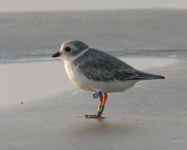
Piping Plover (Charadrius melodus)Observer
mikaelbDescription
Taken while birding the Tony Amos beach, the 7.3 miles between Access Road 1 and Access Road 2.
Banded Piping Plover
PIPL FY(40E)/-:X/-
Photos / Sounds

What
Piping Plover (Charadrius melodus)Observer
mikaelbDescription
Taken while birding the Tony Amos beach, the 7.3 miles between Access Road 1 and Access Road 2.
Banded Piping Plover
PIPL X/-:FY(27T)/-
Photos / Sounds

What
Piping Plover (Charadrius melodus)Observer
mikaelbDescription
Taken while birding the Tony Amos beach, the 7.3 miles between Access Road 1 and Access Road 2.
Banded Piping Plover
PIPL FY(60R)/-:X/-
Photos / Sounds

What
Piping Plover (Charadrius melodus)Observer
mikaelbDescription
Taken while birding the Tony Amos beach, the 7.3 miles between Access Road 1 and Access Road 2.
Banded Piping Plover
PIPL FC(A02)/YC:X/CG
Photos / Sounds

What
Piping Plover (Charadrius melodus)Observer
mikaelbDescription
Taken while birding the Tony Amos beach, the 7.3 miles between Access Road 1 and Access Road 2.
Banded Piping Plover
PIPL FY(9G2)/GW:X/OK
Photos / Sounds

What
Piping Plover (Charadrius melodus)Observer
mikaelbDescription
Taken while birding the Tony Amos beach, the 7.3 miles between Access Road 1 and Access Road 2.
Banded Piping Plover
PIPL FY(S72)/-:X/-
Photos / Sounds

What
Piping Plover (Charadrius melodus)Observer
mikaelbDescription
Taken while birding the Tony Amos beach, the 7.3 miles between Access Road 1 and Access Road 2.
Banded Piping Plover
PIPL FY(8N2)/-:X/-
Photos / Sounds

What
Piping Plover (Charadrius melodus)Observer
mikaelbDescription
Taken while birding the Tony Amos beach, the 7.3 miles between Access Road 1 and Access Road 2.
Banded Piping Plover
PIPL -/GY:FG/KO
Photos / Sounds

What
Piping Plover (Charadrius melodus)Observer
mikaelbDescription
Taken while birding the Tony Amos beach, the 7.3 miles between Access Road 1 and Access Road 2.
Banded Piping Plover
PIPL X/KW:FY(5T3)/PG
Photos / Sounds

What
Piping Plover (Charadrius melodus)Observer
mikaelbDescription
Taken while birding the Tony Amos beach, the 7.3 miles between Access Road 1 and Access Road 2.
Banded Piping Plover
PIPL FY(J45)/-:X/-
Photos / Sounds

What
Piping Plover (Charadrius melodus)Observer
mikaelbDescription
Taken while birding the Tony Amos beach, the 7.3 miles between Access Road 1 and Access Road 2.
Banded Piping Plover
PIPL -/CY:FG/GO
Photos / Sounds

What
Piping Plover (Charadrius melodus)Observer
mikaelbDescription
Taken while birding the Tony Amos beach, the 7.3 miles between Access Road 1 and Access Road 2.
Banded Piping Plover
PIPL X/-:FG/RK
Photos / Sounds

What
Piping Plover (Charadrius melodus)Observer
mikaelbDescription
Taken while birding the Tony Amos beach, the 7.3 miles between Access Road 1 and Access Road 2.
Banded Piping Plover
PIPL X/KK:FY(2R3)/LG
Photos / Sounds

What
Piping Plover (Charadrius melodus)Observer
mikaelbDescription
Taken while birding the Tony Amos beach, the 7.3 miles between Access Road 1 and Access Road 2.
Banded Piping Plover
PIPL FY(2S0)/-:X/-
Photos / Sounds

What
Piping Plover (Charadrius melodus)Observer
mikaelbDescription
Taken while birding the Tony Amos beach, the 7.3 miles between Access Road 1 and Access Road 2.
Banded Piping Plover
PIPL FY(75R)/-:X/-
Photos / Sounds

What
Piping Plover (Charadrius melodus)Observer
mikaelbDescription
Taken while birding the Tony Amos beach, the 7.3 miles between Access Road 1 and Access Road 2.
Banded Piping Plover
PIPL FG/P:-/LY
Photos / Sounds

What
Piping Plover (Charadrius melodus)Observer
mikaelbDescription
Taken while birding the Tony Amos beach, the 7.3 miles between Access Road 1 and Access Road 2.
Banded Piping Plover
PIPL X/KC:FY(L80)/KW
Photos / Sounds

What
Red Knot (Calidris canutus)Observer
mikaelbDescription
Taken while birding the Tony Amos beach, the 7.3 miles between Access Road 1 and Access Road 2.
Photos / Sounds

What
Semipalmated Plover (Charadrius semipalmatus)Observer
mikaelbDescription
Taken while birding the Tony Amos beach, the 7.3 miles between Access Road 1 and Access Road 2.
Photos / Sounds

What
Snowy Plover (Anarhynchus nivosus)Observer
mikaelbDescription
Taken while birding the Tony Amos beach, the 7.3 miles between Access Road 1 and Access Road 2.
This Snowy Plover was in a group of 6, and looked a little strange it me. I think it's missing some tail feathers. And one leg looks orange.
Photos / Sounds

What
Piping Plover (Charadrius melodus)Observer
mikaelbDescription
Taken while birding the Tony Amos beach, the 7.3 miles between Access Road 1 and Access Road 2.
Banded Piping Plover
PIPL FY(90E)/-:X/-
Photos / Sounds

What
Rambur's Forktail (Ischnura ramburii)Observer
mikaelbDescription
Taken while birding the Tony Amos beach, the 7.3 miles between Access Road 1 and Access Road 2.


Comments
The banded BB Plover is really interesting. In the summer months this bird is somewhere in the Arctic, but it comes home to Mustang Island in the fall/winter. I have the info on where to report the bands on the Piping Plovers, Mikael, if you don't have it.
Thanks Greg, I'm exchanging emails with David Newstead who banded that Black-bellied Plover. I reported it to www.bandedbirds.org.
There's also this site:
https://www.pwrc.usgs.gov/BBL/
And this site:
https://www.fws.gov/northeast/pipingplover/report_bands.html
Which do you use?
The yellow flagged birds are banded by USGS and I have the email of the person who runs that. The green flagged birds are banded by Virginia Tech and the blue flagged birds bu Univ. of Nebraska. Send me an email if you want the emails of the various folks who are involved. But I'm sure they will get to the correct people in the web sites you mention.
Here's the USGS contact I used recently:
Please Report Bands at
www.reportband.gov or
call 1-800-327-BAND
The email came from:
BandReports@usgs.gov
Great idea! Include all of Texas. Here are two sightings I have:
https://www.inaturalist.org/observations/2691179
https://www.inaturalist.org/observations/3100338
"All of Texas" would have the same problem as retention ponds. Can anyone figure how to create a project for a specific type of observation, i.e., retention ponds or banded birds, that wouldn't collect all observations in a specific geographical area?
Can inat program something like ebird's "hot spot"?
Thanks Theresa! Right, it would have a similar issue as our idea for a project for retention pond observations. It would rely on human curation, both to add appropriate observations and remove inappropriate ones. I'm wondering if any of the banders would be interested enough in something like this to help with this kind of curation.
I've invited both of you to a test project I created called "Banded Shorebirds."
Also, you both photographed the same PIPL (5C7) in Galveston:
https://www.inaturalist.org/observations/3100338
https://www.inaturalist.org/observations/2010144
https://www.inaturalist.org/observations/1369885
Add a Comment